



Climax
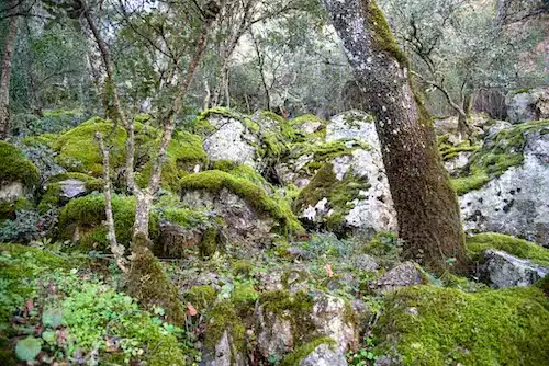
The most mature stage of vegetation under today's climate.
Cabañeros National Park
From dry ridges to peat bogs: why each corner of Cabañeros grows what it grows.
Start with the landscapes7 chapters with drawings · 16 more minutes if you open the full texts
1Introduction
Cabañeros is one of the best examples of Mediterranean forest in the Iberian Peninsula: shady woods, dehesas, scrub, rocky outcrops, riverside woods and water plants, with at least 32 habitats of community interest.1
32 habitats of community interest
Cabañeros is, without doubt, one of the best representations of Mediterranean woodland on the Iberian Peninsula. Its natural value lies in a mix of geological, ecological and anthropological agents that have shaped this unique setting throughout history. Its vegetation is made up of a wide variety of very different landscapes, such as shady woods, dehesa systems, sparse scrub, communities on rock, gallery woods and aquatic vegetation. It is home to at least 32 habitats of Community interest, included in the European Union’s Habitats Directive 92/43/EEC.
In this section on the flora of Cabañeros we will look at the main plant communities, taking into account their floristic composition, spatial distribution, ecology and conservation. The aim is to interpret the landscape in terms of variables such as altitude, aspect, topography or human action.
2Climate
A Mediterranean climate: three to five months of summer drought and very irregular rainfall, from less than 200 mm in some years to more than 1,000 in others.2 And inside the park it does not rain the same everywhere.
The rain is brought by the ábregos, wet south-westerly winds from the Atlantic that lose their water as they move east.
In summer the Azores anticyclone moves up to our latitude and acts as a wall: the storms from the west cannot get through.
From 750 mm a year at Navas de Estena, in the north-west, to 450 at El Torno, in the south-east.3
Schematic; the park boundary, from OpenStreetMap.
As you climb, the air gets colder: about 1 °C every 150 metres. Between the raña, at about 600 metres, and the top of Rocigalgo, at 1,449, there are about 5 °C of difference.4
−5.7 °C less than on the raña
By day, the air in the valleys warms up first and rises up the slopes: these are the anabatic winds.
On cold, clear nights the opposite happens: the freezing air flows down and settles in the valleys (katabatic winds). It is colder at the bottom than at the top, which is called a temperature inversion, and with what little moisture there is, seas of clouds form.
The mountain ranges run east to west, so they have a north face, the shady slope or umbría, and a south face, the sunny slope or solana. They get such different amounts of sun, heat and moisture that each one grows different vegetation.5
The physical environment is decisive for the plant setting. Factors such as climate, geology and topography influence plant species and let us understand their presence or absence in a particular place. The factors can be:
The park’s climate is Mediterranean, characterised by a long summer drought –three to five months–, high temperatures and irregular rainfall, depending on the frequency and origin of the storms. So there are years with under 200 mm and others that exceed 1,000 mm. The rainiest part of the park is the western one, where the most active storms come in.
However, the Mediterranean climate of Cabañeros is tempered by the presence of the east–west Montes de Toledo and by the park’s own location on the Iberian Peninsula. Its relative closeness to the Atlantic Ocean produces a rainfall gradient and a temperature gradient, both linked to the arrival of Atlantic winds, which bring most of the rain.
The winds that bring the main rains to Cabañeros are called <<«ábregos»>>. They are damp winds from the south-west that weaken as we move east. In summer the Azores high moves north to our latitude and creates a barrier that stops westerly storms from coming in.
Altitude plays a fundamental role in recorded rainfall and temperature. The thermal stratification of the park can be worked out with the dry adiabatic lapse rate. The dry adiabatic lapse rate states that when a volume of air is forced to rise (by a rise in the ground, for example), it cools without losing energy as heat.
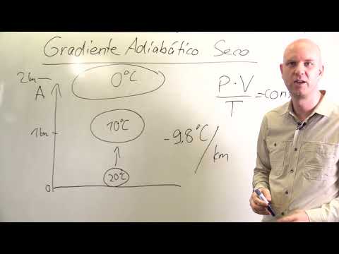
So, under pressure and temperature conditions close to the earth’s surface, the lapse rate tells us that temperature falls 1 ºC for every 150 metres of climb, so there is a difference of about 5 ºC between the highest points (~1,400 m) and the lowest (~600 m). In winter, though, the opposite can happen: the effect of thermal inversion, in which temperature rises with altitude. On clear, cold winter nights the air near the surface cools so fast that it cannot rise. And since the little moisture there is concentrates in the valleys and flat areas, the famous <<seas of cloud>> of Cabañeros appear.

There is also a rainfall gradient that increases with altitude, where rain rises on the most prominent mountain elevations, such as the Rocigalgo, at 1,449 metres. Although there are no great differences in altitude in the Montes de Toledo, the temperature and rainfall gradients have given rise to different vegetation belts, more or less distinctive, according to the existing drop in height.
In conclusion, the rainiest part of Cabañeros lies at higher altitudes in the west, specifically around the Rocigalgo massif, whose annual rainfall is about 1,000 mm. Precipitation as snow usually falls once a year on the north face of the first spurs of the Montes de Toledo, as in the Sierra del Castañar or at San Pablo de los Montes, including, of course, the Rocigalgo. By contrast, the driest part is in the north-west of the district, in places sheltered from the «ábrego» winds and on the lee side, where rainfall reaches only 400 mm a year.
The interior depressions of Cabañeros, such as the valleys of the Estena, the Upper Bullaque or Las Navas, are considered the intermediate conditions of the district, with rainfall close to 600 mm a year, which serves us as a reference for determining the climate of Cabañeros in detail.
As for temperatures, they show greater continentality as we approach the eastern sector, where oceanic winds have less flow. As a result there is a gradual rise in temperature from the north-west to the south-west.
Given the undulating topography of the park, there are different winds that vary with temperature and time of day:
However, the Appalachian-type relief of Cabañeros has a marked east–west direction that gives two predominant aspects: north (shady side, «umbría») and south (sunny side, «solana»). These areas receive such contrasting sunshine that it affects temperature, the amount of light received and surface moisture. The difference in aspect changes the ecosystem, giving completely different vegetation on each slope.
The relative continentality mentioned above in the north-east, near El Molinillo, is a notable feature of Cabañeros. There is a large difference between the minimum and maximum annual temperatures, which reaches 45 ºC. The same goes for the daily range, which averages 12 ºC and reaches 20 ºC in spring and autumn.
The thermotype is an index that measures thermal parameters, and the one that predominates in Cabañeros is called mesomediterranean. Although in the highest, coldest areas such as the Rocigalgo there are supramediterranean enclaves.
Among the factors that affect plant development, it is important to bear in mind that temperatures set the qualities of vegetation and its possible development. For example, below 7.5 ºC vegetative activity is so limited that biomass hardly increases. On the other hand, exposure to light defines the energy received and photosynthetic activity. The figures for Cabañeros are as follows:
The shape of the vegetation itself can create variations in climate, such as the crowns of holm oaks (Quercus), which create microclimates beneath them by not letting rays of light in or by reducing the intensity of frosts, giving different compositions of herbaceous species.
3Relief and soils
The relief of Cabañeros can be simplified into three positions: dry ridges, middle slopes and wet valleys. Each has its own soil, and each soil its own plants.10
Lithosol · Ridge. Almost bare rock, on steep ground and constantly eroded. Only plants that live in cracks grow here, such as the rock pink.
Ranker · Steep slope. Soil less than 20 cm deep over slate or scree. Rockrose, heather and French lavender scrub.
Brown forest soil · Slope. Rich in organic matter, crumbly and full of roots: the best soils for woodland, with Portuguese oak, Pyrenean oak, strawberry tree, holm oak and cork oak.
Raña soil · Plain. With a lot of clay and quartzite cobbles, poor in nutrients. Many were farmed because they were easy to reach.
Peaty soil · Hollow. Peat bogs, bonales and quaking bogs: always waterlogged, with undecomposed organic matter. Specialised plants live here, many of them protected.
Geomorphologically, Cabañeros and the Montes de Toledo show a marked Appalachian-type relief. They lie in the south-eastern sector of the Central Iberian zone of the Hesperian Massif and contain the core of ancient Precambrian and Palaeozoic rocks. Their materials are organised into two large groups that shape the relief of Cabañeros:
Armorican quartzites are the geological skeleton of the Montes de Toledo. They are very hard metamorphic rocks that easily resist erosion for millions of years. So much so that they are the ones that have formed the sierras and valleys by lasting longer than more erodible materials. These mountains formed about 300 million years ago, and between the quartzite crests rivers slip through and give rise to waterfalls such as the Boquerón del Estena or La Chorrera. Before their formation, continual marine transgressions left numerous marine fossils, among which trilobites stand out, and these can be seen today on many of the park’s routes.
The relief of Cabañeros can be simplified grosso modo into crest–slope–valley to understand the distribution of the main vegetation types:
This simple classification makes it possible to place plant communities in a simplified way. Given the east–west orientation of the mountain ranges in the Montes de Toledo, another factor for understanding the distribution of vegetation is slope aspect, whether shady or sunny. The first demands more moisture, while the second stands up better to dryness.
However, it is the soil that supplies the air to breathe, the water and the nutrients needed for plant development. According to the physiography of the land, soils are divided into two:
4Water
Almost the whole park, 95.5 %, drains into the Guadiana.11 It has around a thousand kilometres of seasonal streams and a few dozen kilometres of rivers that never dry up.
About 1,000 km of streams that dry up in summer
A few dozen kilometres of permanent rivers
Each line, 50 kilometres.12
On the rañas the clay does not let water through, and seasonal lagoons form on the flat ground. The largest, on the Raña de Horcajo, covers 9.64 hectares, is less than 80 cm deep and dries up around June.13
Cabañeros lies almost entirely in the basin of the River Guadiana (95.5 per cent; the rest belongs to the Tagus). The park’s river network is made up of a thousand kilometres of seasonal streams and fifty-odd kilometres of permanent rivers.
Its two main rivers are the Estena, which rises on the Rocigalgo and crosses 40 km of the park, and the Bullaque, at the park’s eastern end. The Estena is in the western part of the park, in more intramontane areas. The Bullaque, with a gentle slope, crosses the raña without deep gorges, except for the Portilla de la Torre de Abraham.
Cabañeros and its surroundings also have some seasonal ponds, among which the Laguna Grande de Alcoba, the Laguna de la Raña de Horcajo –the largest, at 9.64 ha– and the Laguna de los Cuatro Morros stand out. Their waters are oligosaline, that is, they have few dissolved salts, and lack nutrients. They form on the rañas, where the gentle slope and the high impermeability from the high clay content do not allow drainage. They are seasonal and dry up around June. They are less than 80 cm deep, but they sustain a far from negligible amphibious vegetation.
5Concepts
Flora is the list of species; vegetation is how they group together. To read the plant landscape you need a handful of words, and here they are.
Flora is the number and description of the species that live in a place: a list.
Vegetation is how those plants come together in communities: holm oak woods, rockrose scrub, grasslands…
Biogeography studies how living things are spread across the Earth, and it does so in units that fit inside one another, like Russian dolls.
If nobody touches it, vegetation matures to its final stage, the climax: in Cabañeros, holm oak, Portuguese oak, cork oak and Pyrenean oak woods. The stages before are called serial, and a fire or a clearing sends it back.
Serial stagesClimax
The most mature stage of vegetation under today's climate.
The communities that follow one another in the same place, from grassland to forest.
Neighbouring communities that change with one factor: altitude or moisture.
One that has more water than the rain brings, because the soil is wet.
One that gets extra water from time to time, from run-off: the flooded meadows called navas.
One that has less water than the rain brings, because of the soil: ridges and rocky outcrops.
One that never becomes forest but stays in balance: peat bogs, rocky outcrops, screes.
What there would be without human influence. The real vegetation may be rockrose scrub where holm oak would belong.
With two species: one that sets it apart and the one that dominates. Both change their endings, in the Latin of botanists.
wild pearPyrus bourgaeanaPyro bourgaeanae
holm oakQuercus rotundifoliaQuerco rotundifoliae
Pyro bourgaeanae-Querco rotundifoliae S.
Luso-Extremaduran mesomediterranean holm oak woods
Vegetation, or the plant landscape, is the set of plant communities, that is, plants, that live in a given territory. Vegetation refers to the set of plant communities. Flora, for its part, is the number and description of the taxa that live in a place. In short:
Below we briefly define the concepts most used to understand this section.
In this way one can tell apart, for example, the Lusitanian-Extremaduran holm oak woods of Cabañeros, on acid soils, from the La Mancha ones on basic soils.
Mesomediterranean Lusitanian-Extremaduran holm oak woods: Pyro bourgaeanae-Querco rotundifoliae S. The name comes from the dominant species, the holm oak (Quercus rotundifolia = Q. ilex subsp. ballota), and from the Iberian pear (Pyrus bourgaeana), the differential species. The endings are modified:
6Classification
Plant groupings fall into three groups: woods, scrub and shrubland, and herbaceous communities. Each community has its own page.
More or less dense groups of trees: the climatophilous ones and the riverside ones.
Alder woodsAsh woodsBirch woodsCork oak woodsHolm oak woodsPoplar grovesPortuguese laurel grovesPortuguese oak woodsPyrenean oak woods
SeeShrubs under 7 metres and scrub, almost always mixed together.
Broom and retama thicketsHeathlandsMastic and kermes oak thicketsRockrose thicketsStrawberry-tree thicketsTamujo thicketsWillow thickets
SeeFrom plants that live one year to the pastures of the dehesa.
Amphibious, hygropeat and aquatic communitiesDehesasMesophytic communitiesRock communitiesTherophyte communitiesXeromesophytic communities
SeeThey are divided into three groups:
7News
The flora of Cabañeros is very well studied and still keeps surprising us. This is the most striking news from the park newsletter since 2023.
3 volumes
In 2026 the third volume of Vegetación y flora del Parque Nacional de Cabañeros came out, with what was found between 2017 and 2024 and, for the first time, palaeobotany.14
211 lichens
85 new to the Montes de Toledo. The rock with the most species, the Armorican quartzite.15
1st record
Ophrys sphegodes appeared in 2024 next to Casa Palillos. Orchids must not be picked: they need a soil fungus to germinate.16
80,000 trees
Holm oaks, cork oaks and Portuguese oaks grown from acorns collected in the park, on some 290 hectares, in the winter of 2022-2023.17
The flora of Cabañeros is very well studied, and yet it still holds surprises. The most striking of what the park newsletter has reported since 2023 (all the newsletters):
↑↓ to move · Enter to open · Esc to close


